Infrastructure of the Image
Susanna Collinson
[ PDF Version ]
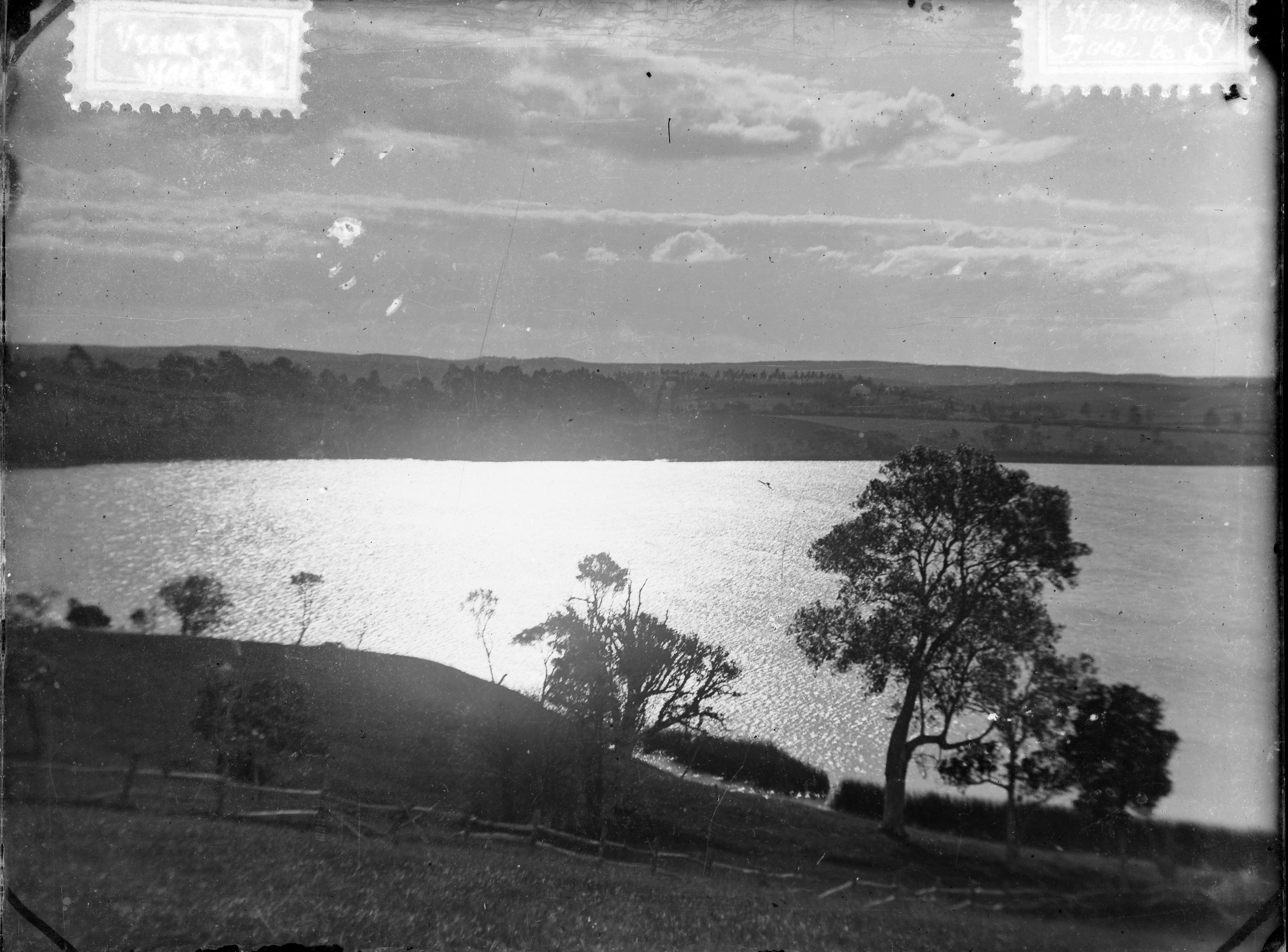
Fig. 1. Showing an unidentified view, probably somewhere in the Waikato, looking out to sea.[1]
I begin from a black and white photograph of a landscape. On the surface, both the photo and its description seem to cohere; however, this bare description reveals more about the concept of the image than what it might directly illustrate. In an Indigenous place, landscapes are a settler category of control, critical to the expropriation of land. The viewer is positioned on the outside; the camera allows for a stranger to the land to enforce their own taxonomies onto longer Indigenous histories of place. Yet as Christopher Pinney points out, “the inability of the lens to discriminate will ensure a substrate or margin of excess, a subversive code present in every photographic image that makes it open and available to other readings and uses.”[2] This text will look into the image, turning it back upon itself to reveal its structure and interrogate its settler-colonial frame. Consequently, the image opens up space for a counter-colonial reading, where the settler’s carefully constructed boundaries between image and place become precarious. Landscape photographs mirror the relationship between the virtual and actual in the infrastructure of settler colonialism; this essay argues that understanding their limits offers an opportunity to unsettle the larger colonial project.
Lisa Parks and Nicole Starosielski point out that “how content moves through the world” inevitably affects its form.[3] This claim is true as much historically as it is with respect to contemporary digital technologies, as is made particularly apparent from Aotearoa/New Zealand’s position on the “far” side of the Pacific Ocean. It is impossible for humans to access this place without a highly developed infrastructure of their own–a voyager must be able to make ocean-going vessels, to navigate by the stars, and record a way for others to follow. Of course, these movements across the world are also layered; Māori had already been in Aotearoa for hundreds of years before European powers-to-be were even aware of its existence. This historical relationship inevitably forms the infrastructure which would develop from the moment of contact. Filmmaker, writer, and thinker Barry Barclay (Ngati Apa) writes, “You look at Cook as a man who went out to the farthest ends of the earth. We see him simply as a man who arrived. Our people saw him arrive. We saw what he did. You will use the images to present a hero. But he was an invader to us.”[4] Photographic technologies allowed colonists to take images of so-called new and empty lands back across the sea, where they fed imperial archives. In those archives, the images acquired new contexts, likewise affecting their form. Reflecting on a presentation given by Italian film archivist Paolo Cherchi Usai, Barclay comments that to get basic information about the provenance and purpose of an image–what it might be an image of–“the archivist need[s] to look for clues in materials beyond the image itself, labels on the film cans, for example, or film crew records found inside the cans.”[5] There is something invisible, in excess, “beyond” the image when it moves through the world, and especially when the image moves through the infrastructure which enables it to cross the time and places of Moana-a-kiwa.
I came across the image above, entitled “Unidentified Image: Looking Out to Sea,” in the photographic archives of Auckland Libraries. I was searching for photographs that were not what Joel Snyder calls “acceptable images.” Here, the ocean—Moana-a-kiwa—magnifies the sunlight, burning through the center of the photograph, indexing the presence of something more than a landscape. To make an acceptable image, the photographer must use the mechanisms within the camera to control light, letting in only enough to create a scene recognizable to the human eye. Too much light and the resulting picture will be overexposed, appearing washed or burned out. Too little light and the picture will be murky, making only a suggestion of form in the darkness. Of course, as Snyder points out, there are degrees within the framework for what makes an acceptable picture.[6] The above photograph still evinces a visible landscape. In the archive, this photograph is categorized as “showing an unidentified view,” “unidentified” here meaning unable to be placed according to geographic logic of space. However, the print bears the marks of its containment–in particular, the tape marks from where it has been placed in an album.
The description further says that the photograph is “looking out to sea,” but which/what sea? How can you understand unidentifiable images? What makes a photograph unidentifiable? As Lisa Gitelman puts it, “Media muddy the map.”[7] Far from providing an accurate picture of the past, the image, as “both evidence and cause of its own history,” creates a temporal loop, where the knowledge it bears—what it might bear the knowledge of—is at once present and removed.[8] This knowledge is “removed,” as Barclay indicates, because simply viewing images is not enough to make them intelligible and makes them give up their context.[9] On one level, the unidentifiable nature of the image belies its relation to the conventions of mapped geographic space. The caption notes that it is “probably somewhere in the Waikato.” It would be possible to do some detective work–the coastline of the Waikato region is limited compared to many places in Aotearoa/New Zealand, with a stretch of coastline from Matira to Makomako in the west, and a small section of the Firth of Thames surrounding Miranda. Yet, specifying the exact location of this scene would do nothing to ease the uncomfortable present-yet-absent affect produced by this photograph.
Another level to its un-identity is the lack of a known photographer. The very existence of the photograph indexes a photographer, someone to focus the lens, set the exposure time and aperture, and release the shutter. The transition from analogue to digital photography in the years since this image was made has, of course, changed these conditions. The automation of the photographic process means that an image no longer indexes a human producer. In fact, the development of computer-generated imagery (CGI) means that an image no longer necessarily indexes the presence of a camera. In their introduction to Digital Light, the editors write:
There is a story that the very first filter invented for Photoshop was the lens-flare [. . .] It also draws attention to the apparatus of picture-taking, and when used for effect transforms it into picture-making [. . .]. Its first use would be precisely to emulate the photographic apparatus in shots that had been generated entirely in CGI (computer-generated imaging), where it was intended to give the illusion that a camera had been present, so increasing the apparent realism of the shot. The defect became simulated evidence of a fictional camera: a positive value.[10]
The lens flare in the unidentified view is “real,” rather than filtered, but the image I have been looking at is still a digital (pixelated) reproduction of the “original” analogue image, which begs the question of the relationship between these versions. The analogue print is an index of its negative, while the digital sits beside the analogue print as a copy or doppelgänger. There is a thickness created by the strata of the image, with the relationships between the layers forming a photographic media infrastructure. Photography as a media infrastructure operates on both macro and micro scales. The originary grains of the analogue print are re-imaged into pixels, and those pixels into data. Somewhere along the way, an image of Moana-a-kiwa—the Pacific Ocean—becomes equally “a sea of data.”[11] With regard to encrypted images from Edward Snowden’s NSA files, Hito Steyerl writes that the “secret” to seeing these images is in pattern recognition: “Doesn’t it look like a shimmering surface of water in the evening sun? Is this perhaps the ‘sea of data’ itself? An overwhelming body of water, which one could drown in? Can you see the waves moving ever so slightly?”[12] The slippage Steyerl indicates–an image of data that appears to be ocean—like, a single point in an overwhelming amount of collected data—mirrors the image above, where the relationship between light and water too has a scrambling effect, one that cannot be fully contained by camera technology, human vision, or archival authority.
Steyerl claims that “not seeing anything intelligible is the new normal. Information is passed on as a set of signals that cannot be picked up by human senses.” In settler colonial states, however, the limits of vision have long been called into question, both by Indigenous people asserting their own cosmologies and by settlers anxiously arriving in “strange” new places. Ani Mikaere points out that “for Māori, the coexistence of the seen and the unseen is entirely natural.”[13] On the “settler” side, environmental historian Geoff Park comments that “being colonial in matters of land and country is quintessentially about being preoccupied by what the strangely different looks like. Colonial eyes see from the outside what the mind that informs them has learned, elsewhere, to see.”[14] Today, settler states seek to alleviate this ongoing anxiety through infrastructures of surveillance. It is no coincidence that Snowden’s leaked NSA files revealed that the Five Eyes Network is composed of Britain and its four largest English-speaking settler colonies. Located around the rim of Moana-a-kiwa, this network reanimates geopolitical lines constructed by the voyages of Cook and other imperial figures. The infrastructure of the Five Eyes Network also facilitates the sea of data, creating a virtual analogue of the waters it spans, and which, in the case of undersea cables, it runs through. However, this versioning of the Pacific Ocean ignores other, already extant infrastructures, such as Moana-a-kiwa as “a sea of islands,” or the excess of light reflected off the water and burning through the lens, suggesting some larger cosmological “unseen.”[15]
The importance of infrastructures that work with invisible materials has featured in the Waitangi Tribunal in recent years, most notably in the Radio Spectrum Management and Development claim (Wai 776). Rangiaho Everton brought the claim that the radio spectrum was a taonga natural resource, made on the basis of Article Two of Te Tiriti o Waitangi (the Treaty of Waitangi). This document has its own long history of contested, and thus, excesses of meaning, derived mostly from inaccurate translation between the Māori and English versions of the text.[16] Article Two guarantees Māori tino rangatiratanga (chiefly authority) over their taonga (treasures), including resources such as fisheries and forestries. In the Radio Spectrum case, the Crown argued that the radio spectrum was both artificially generated and undiscovered as of 1840, and so could not be classified as a taonga resource.[17] The majority opinion of the Waitangi Tribunal, however, argued that “the right [to development of resources] cannot be fossilized as at 1840 and limited only to resources known or used back then.” Drawing on expert knowledge from kaumatua such as Professor Hirini Mead, the Tribunal pointed out that radio waves are composed of light and sound, which Māori were both aware of and utilized: the spectrum facilitated the light of the stars for navigation across the ocean. The tribunal explained that while lacking the technology to enhance use of the radio spectrum in 1840 (as indeed did settlers) the connection between light, sound and knowledge was “incorporated into their own philosophical world view [for example] Tawhaki climbing the heavens to bring to earth knowledge, education, and sacred incantations for the spiritual wellbeing of the people.”[18]
The focus of reparations on the state of affairs in 1840 suggests that settler-colonial infrastructure must necessarily be explored as part of a media archeology. Lisa Gitelman states that “media are unique and complicated historical subjects. Their histories must be social and cultural, not the stories of how one technology leads to another, or of isolated geniuses working their magic on the world.”[19] Infrastructures of vision operate diagrammatically through time and space rather than following a strict narrative of chronological “progress.” The movement of a photograph of the supposed past (from analogue to digital), and the relational existence of radio waves (then and now), articulate what Parks calls an “invisible adjacency” of past and present, space and place. Technology, then, has “the capacity to recognize the presence and significance of a material field, object and/or body without directly sensing it.”[20] Given the historical dislocations which emerge when infrastructures of vision are called into question, the supposedly unidentified image can be read as future potential, a holding pattern until the pathways that the “unidentified sea” constructs through space and time can be reactivated, a type of infrastructure which resists its own imprisonment (the tape marks, now burnt through) in the settler archive.
Notes
[1]Unknown, (1880-1889) Auckland Libraries Heritage Collections 1058-9875.
[2] Christopher Pinney, Photography’s Other Histories (Durham, NC: Duke University Press, 2003), 6.
[3] Lisa Parks and Nicole Starosielski, eds. Signal Traffic: Critical Studies of Media Infrastructures (Urbana IL: University of Illinois Press, 2015), 1.
[4] Barry Barclay, Mana Tuturu: Māori Treasures and Intellectual Property Rights (Honolulu: University of Hawaii Press, 2006), 15.
[5] Ibid., 16
[6] Joel Snyder and Neil Walsh Allen, "Photography, Vision, and Representation,” Critical Inquiry 2, no. 1 (1975): 162.
[7] Lisa Gitelman, Always Already New: Media, History and the Data of Culture (Cambridge, MA.: MIT Press, 2006), 4.
[8] Ibid., 10.
[9] Barclay, Mana Tuturu, 16.
[10] Sean Cubitt, Daniel Palmer, and Nathaniel Tkacz, “Materiality and Invisibility” in Digital Light (London: Open Humanities Press, 2015), 7.
[11] Hito Steyerl, “A Sea of Data: Apophenia and Pattern (Mis-)Recognition,” E-flux Journal 72 (2016).
[12] Ibid.
[13] Ani Mikaere, “Some Implications of a Māori Worldview,” Colonising Myths—Māori Realities: He Rukuruku Whakaaro (Wellington: Huia Publishers, 2011), 368.
[14] Geoff Park, Theatre Country: Essays on Landscape & Whenua (Wellington: Victoria University Press, 2006), 96.
[15] Epeli Hau’Ofa, "Our Sea of Islands," A New Oceania: Rediscovering Our Sea of Islands (Suva, Fiji: School of Social and Economic Development, The University of the South Pacific, 1993), 2–16.
[16] There is a significant body of scholarship regarding this issue. See, for example: Margaret Mutu, “Constitutional Intentions: The Treaty of Waitangi Texts,” in Weeping Water: The Treaty of Waitangi and Constitutional Change, ed. Malcom Mulholland and Veronica Tawhai (Wellington: Huia Publishers, 2010), 13–40; Vincent O’Malley, Bruce Stirling, and Wally Penetito, eds., The Treaty of Waitangi Companion: Māori and Pākeha from Tasman to Today (Auckland: Auckland University Press, 2010).
[17] Waitangi Tribunal, Radio Spectrum Management and Development Final Report (Wai 776, 1999), 31.
[18] Ibid., 41–42.
[19] Lisa Gitelman, Always Already New, 7.
[20] Lisa Parks, “Mapping Orbit: Toward a Vertical Public Space,” in Public Space, Media Space, ed. Chris Berry, Janet Harbord and Rachel O. Moore (New York: Palgrave Macmillan, 2013), 83.
Susanna Collinson is a Ph.D. student in Visual Studies in the History of Art and Visual Culture Department (HAVC) at UC Santa Cruz, with particular research interests in histories of photography, critical legal geographies, settler colonial studies, Indigenous studies, Infrastructure, archival theory, landscape photography, outer space, new media and design.
 Media Fields Journal