Urban Labyrinths, Ariadne's Threads, and GPS Data: Logging and Drawing Trajectories with a GPS Personal Navigation Device
Andres Lombana Bermudez
[ PDF Version ]
I. Entrance
When we move carrying GPS-enabled devices such as smart phones or personal navigation assistants we generate GPS data that is recorded in digital files. Sometimes we consciously record them like when using an ad-hoc application for visualizing our cycling routes, other times they are recorded by service providers for security purposes without even noticing it (e.g. car rentals, telephone companies). Those GPS logs are traces that document our movements in both the physical space of the world, and the virtual space of the Global Positioning System. When visualized over digital maps, both in real-time or after we have finished our journeys, the traces become concrete representations of our trajectories. They are records of our itineraries, material drawings of our routes in hybrid space.
I argue that there is a poetics of creating GPS traces in the hybrid physical/virtual space of a city. When we record GPS data while moving inside a city we make an artifact and perform an action, we articulate a speech act. Poetics derives from the ancient Greek word Poïesis which means "active making." Although traditionally poetics was applied to the study of epic and tragedy (Aristotles), poetics is not restricted to any particular medium (e.g. Stravinsiky’s poetics of music, Tzonis’ poetics of architecture, Bordwell’s poetics of cinema). The study of the process of crafting GPS traces inside the hybrid space of a city, their function, effects, and uses, compose together the poetics of a geolocative media practice. In an effort to explore the poetics of this process I have been developing a ludic operation in the different urban centers I have lived and visited. I have imagined this practice as a performance in which one draws, with the help of a GPS personal navigation device, labyrinth trajectories.
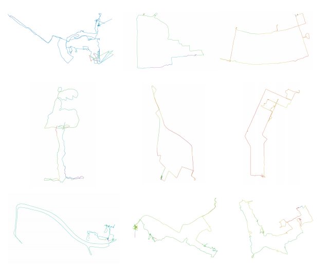
Figure 1. Nine Cities
In this essay I present a selection of nine drawings performed in different cities around the world (Amsterdam, Austin, Bogota, New Orleans, New York City, Paris, Prague, Rotterdam, and Somerville-Cambridge). Each of these drawings is a visualization of the GPS logs I have recorded as I traverse and explore a particular city. They are visualizations of the GPS data I have generated while walking, cycling, or riding a form of public transportation. They are memories of an urban speech act. During the drawing performance I re-appropriate both the physical space of the city and the virtual space of a scientific model of the world (visualized on the screen of the personal navigation device) in order to generate a canvas for a labyrinth trajectory. Superimposed, these spaces compose a hybrid background where I can draw with my movement as if I had an Ariadne's thread. In this essay I complement the displaying of these drawings, with a reflection on the meanings of this creative practice.
II. The Poetics of Transiting Hybrid Space [Movements in the City]
The development of the Global Positioning System, ubiquitous computing, the Internet, and digital mapping has transformed the way in which we experience the city. We are becoming use to navigating streets with the aid of real time computations, digital map visualizations, and signals broadcast by space vehicles that orbit planet earth. With GPS data, another layer of networked information has been added to the city’s increasing complexity. As Freidrich Kittler states, "in the city, networks overlap with other networks." Networks that transmit energy (electricity, supply, highway, street) intersect with networks that transmit information (telephone, radio, television, Internet, GPS). Urban mobility is a hybrid experience of spatiality in which we navigate at the same time physical and virtual space.
Not all urban movements generate the same kind of engagement with the networked environment and have the same outcome. We can consider two broad categories of urban mobility. One kind of mobility is rational, proper, and disciplined. It usually involves going from point A to point B in the shortest period of time, taking a few turns, and using conventional routes. It has a concrete purpose. Examples of this kind of trajectories are the trips we make when we go to work, to the grocery store, or the ones suggested when we ask for directions in a website such as Map Quest or Google Maps. Other kind of mobility is experimental, undisciplined, and improper. It lacks specific purpose and its time duration is open ended. Some of the exemplary cases of this kind of movements are the wanderings of surrealists, the strolls of flâneurs, and the dérives (driftings) of situationists. Although walking has usually been privileged for performing this kind of undisciplined mobility, the urban movements of skaters, cyclists, and even some commuters could also be considered under this category, especially when they break the logic of the traffic system and transform urban spaces with their actions.
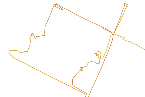
Figure 2. Detail from Moon Cow. Movements on a bicycle through alleys, parking lots, and streets in Hyde Park. Austin, TX, USA.
There is a whole literary and artistic tradition that has explored the creative, critical, and experimental potential of moving inside a city. In the 19th and 20th centuries, flâneurs, surrealists, situationists and other radical artists and writers explored the possibilities of browsing city networks for spatial and psychogeographical investigations. According to this tradition, urban mobility has been a method for learning about spaces, peoples, landscapes, and environments, and for discovering their poetic potential. Masters of "flanerie" such as Nerval, Baudelaire, Apollinaire and Benjamin discovered the kaleidoscopic aspects of the city while strolling and made the streets their home. Surrealists' aimless deambulations such as the ones of Breton and Aragon, allowed them to exalt random, marvelous and unknown encounters. Their walks were kind of unconscious acts guided by the repulsions and attractions they found in the environment.[1] Situationists and lettrists practiced the dérive (drifting) as a systematic technique for researching the psychological interactions with the urban environment. Despite the similarities among the members of this tradition of mobility, the differences between them are related to their political intentions. While flâneurs and surrealists submitted their strolls and wanderings to unconscious desires, situationists were engaged in subversive politics and tried to change the urban environment by the creation of situations.[2]
The conceptualization of psychogeography is key to understanding the evolution of the creative, critical, and experimental tradition of urban mobility. In "Introduction to a Critique of Urban Geography" (1955), Guy Debord defines psychogeography as "the study of the specific effects of the geographic environment, consciously organized or not, on the emotions and behaviors of individuals." For Debord, urban mobility becomes both a systematic investigation of the environment and an "insubordination to habitual influences."[3] The dérive, developed first by the International Lettrist Group in 1952, is the main technique and practice for the development of psychogeography. As Debord explains in "Theory of Dérive" (1958), "Dérives involve playful-constructive behavior and awareness of psychogeographical effects, and are thus quite different from the classic notions of journey or stroll." The dérive is a nomadic itinerary that reveals the psychogeographical contours of a city through flowing. According to Debord, "from a dérive point of view cities have psychogeographical contours, with constant currents, fixed points and vortexes that strongly discourage entry into or exit from certain zones."[4]
The practice of drawing labyrinth trajectories in hybrid physical/virtual space belongs to the creative, critical, and experimental tradition of urban mobility I have described above. Although this ludic operation does not try to transform a specific environment and is not politically subversive, it does have elements of the situationists' dérive such as its nomadic quality and the tracing of psychogegraphical contours. Furthermore, the drawing performance also has elements of the surrealists' wanderings such as the exaltation of randomness and the search for unknown encounters. What the drawing of labyrinth trajectories brings to this tradition of urban mobility is mainly the recording and visualization capabilities of GPS-enabled devices and the possibility of interacting with them in real-time. These two characteristics are precisely the ones that allow the performer of urban labyrinth routes to actively and continuously draw in physical/virtual space as she/he moves.
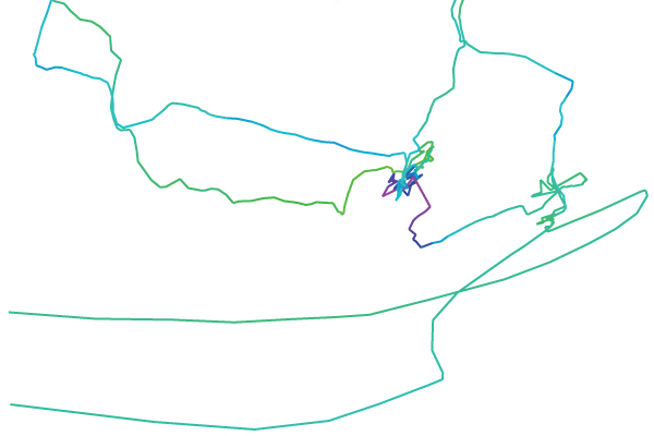
Figure 3. Detail from Big Wale. Walking movements through Het Park and Nieuwe Werk, and ship movements in the river Nieuwe Maas. Rotterdam, NL.
Michel de Certau has articulated one of the most interesting studies of urban mobility. In The Practice of Everyday Life, de Certau has explicitly addressed the poetic aspects of moving through the space of the city, and has particularly focused on the practice of walking. According to him, walking is a space of enunciation. "The act of walking is to the urban system what the speech act is to language or to the statements uttered."5 As a user of the city, the walker makes "speech acts", she/he "enunciates" spaces when decides where to walk, when to turn, where to go. By making these decisions, the walker actively selects urban fragments, creates statements, and practices ellipsis as he also omits whole parts of urban texts. As de Certau explains, "In that way, he makes them exist as well as emerge. But he also moves them about and he invents others, since the crossing, drifting away, or improvisation of walking privilege, transform or abandon spatial elements."[6] Urban turns and detours are turns of phrase and stylistic figures in the "long poem of walking."[7] When the walker does them, she/he manipulates spatial organizations and actively makes something, creating a very poetic act.
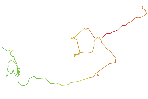
Figure 4. Detail from Gargoyle. Walking movements through the 13th arrondissement. Paris, FR.
Following de Certau, I argue that drawing labyrinth trajectories in hybrid physical/virtual space is a new way of creating “speech acts,” of re-appropriating, at the same time, physical urban fragments and GPS data. While performing labyrinth itineraries I enunciate not only the physical layout of the city but also articulate (and record) the GPS data space, the virtual space of the scientific model of planet earth (Cartesian grid). The "speaking" labyrinth trajectories are creative, experimental, and critical because they manipulate energy and information networks in undisciplined ways. However, these new urban “speech acts” are also ambiguous. Despite the freedom of the improper urban movements, moving in hybrid space also implies moving inside the three-dimensional Cartesian grid that structures the GPS system. This grid is what allows the exact positioning and tracking of any object on the WGS84 map of the world.[8] Hence, despite opening opportunities for freedom and play, the new “speech acts” and drawings could also be criticized, as other new geolocative media practices, for its reliance on a military-scientific-capitalist architecture of surveillance and control.[9]
III. Surveillance, Control and Freedom [Movements in the Outer Space]
As with other space-age technologies, the origins of the Global Positioning System (GPS) can be found in the series of USA military, technological, and scientific developments that the USSR's launching of the Sputnik (1957) triggered at the beginning of the Cold War's Space Race. It was precisely the study and monitoring of the radio signals broadcasted by the Sputnik that allowed USA scientists to determine its exact orbit and realize that the signals broadcasted by space vehicles orbiting planet earth could be used for determining fixed positions on the ground. Fast-forward fifty years and we encounter a fully operating system of satellite navigation globally available for civilian and military use, capable of not only determining with scientific precision the position of any body on earth's surface, but also of keeping the exact universal time all around the world.
Three segments compose the GPS system. First, a space segment composed of 24 satellites in medium Earth orbit (20,200 km above the ground) that circle the planet in a 12 hour period and broadcast signals continuously with information about their position and about the exact time of their atomic clocks; Second, a control segment composed of a network of stations (one master control station is in Colorado Springs, and five monitor stations are in Hawaii, Kwajalein, Ascension Island, Diego Garcia, and Cape Canaveral) on the earth’s surface that track the flight paths of the satellites and three dedicated ground antennas around the world. Third, a user segment that consists of GPS radio receivers that obtain the signals broadcast by satellites and are able to process the different computations and determine the precise position on the Earth. Today, GPS receivers not only come in different presentations such as personal navigation assistants and wristwatches, but also are integrated in a myriad of objects such as cameras, cars, cargo containers, and smartphones.
GPS receivers are basically a hybrid of a radio transistor and a computer. In order to work properly, they have to connect with at least four satellites from the GPS constellation. Receivers tune to the L1 radio signals broadcasted by GPS satellites (frequency of 1575.42 MHz), and decode their message in order to know the positions of satellites and to synchronize their clocks with the universal atomic time (down to the nanosecond).10 Using this information, the receivers are able to calculate a precise location on earth's surface (delivered in longitude/latitude/altitude 3D coordinates) solving a series of mathematical equations. The results of these calculations, expressed accordingly to the WGS84 reference coordinate system, can be visualized on a map representation of planet earth that is usually displayed on the receiver’s screen. Because the GPS receiver can stay tuned (locked) to the satellites and connected to the GPS system for long periods of time, it can also recalculate its position as the user moves on the ground, keeping track of user’s movement over earth's surface and measuring the speed of her/his motion.
The practice of drawing urban labyrinths in hybrid space takes advantage of the GPS infrastructure and re-appropriates it for playful and undisciplined purposes. When turning on a receiver the performer of urban labyrinths connects to the GPS system as part of the user segment. As she/he enters hybrid space and starts drifting and browsing, the performer interacts with a constellation of satellites that are broadcasting radio signals while moving in the outer space. The performance of an urban labyrinth, therefore, becomes a sort of choreography between satellites and the user of a GPS receiver. This dance reveals the ambiguity of such creative media practice. The performer is at the same time “locked” down to the GPS grid, and also is allowed to freely move and draw over a hybrid physical/virtual canvas.
Although GPS navigation is supposed to work well everywhere on planet earth, errors can occur when radio signals are delayed as they pass the ionosphere making difficult to determine the distance of the satellites. Other common errors occur when the GPS receiver is near a large object or inside a closed structure. When this happens, the radio signal bounces giving the receiver the impression that a satellite is further away than it actually is. Visualized on the screen of the receiver (digital map) the location of the user appears to be moving farther away and the GPS trace acquires a glitch-like quality. Long straight lines surround the areas of the GPS trace where the error occurs, and, depending of the duration of the disruption of the radio signal, those lines can create complex pointy shapes. When performing urban labyrinths there is always a risk that unexpected errors will be recorded in the GPS track log and visualized on the screen of the personal navigation device as glitches. Such kinds of signal interruptions remind the performer that her/his navigation of hybrid space is a complex orchestration of physical and data networks. Therefore, the flow of information can be broken and interrupted anytime.11 The glitch in the labyrinth, however, does not destroy the drawing or the performance. Instead of that, it enhances the visual quality of the GPS trace with a noisy texture, and also gives the performer the curious possibility to be unlocked from the grid for a certain period of time.
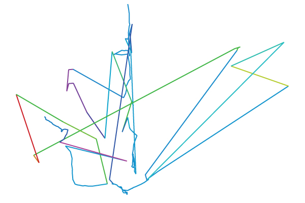
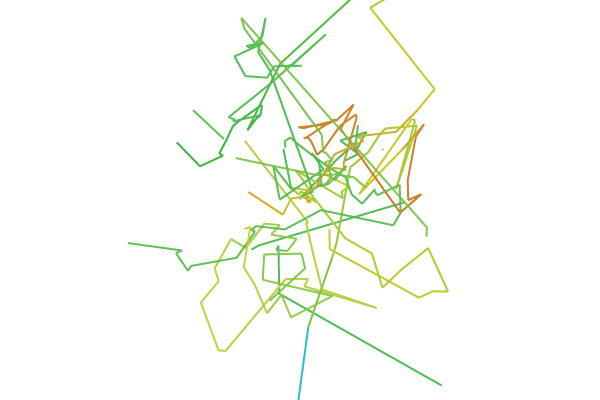
Figure 5. Visualizations of satellite signal bouncing while walking near and inside big buildings. Detail from Ear (top). Walking around the NEMO building. Amsterdam, NL. Detail from Lion (bottom). Walking inside the National Gallery. Prague, CZ.
Since the Global Positioning System is owned and operated by the USA Government as a national resource, the USA military has the ability to deny GPS service to potential adversaries on a regional basis. Even the highest quality signal, also known as the Precise Positioning Service (PPS), continues to be reserved for USA and allied military users. This fact reveals how the GPS has increased the ability of USA to control and monitor world trade, travel, global telecommunications, and commercial remote sensing, using its resources located in the outer space. As Barry Posen argues, “command of space allows the United States to see across the surface of the world’s land-masses and to gather vast amounts of information.”[12] This way of seeing and sensing the world, totalitarian and panoptical, remind us that GPS technology is also used for surveillance and control. Because this technology universalizes time and space it also disciplines us.[13]
Nowadays, there are millions of civil users of GPS technology who have become accustomed to visualizing their position and movements in digital maps according to universal time and geodetic coordinates. GPS receivers are consumed by civilians in ways that are both exercises of freedom and subordinations to control. On the one hand, GPS users can engage in exploratory and creative practices such as hiking a mountain, riding a bicycle through an unknown trail, and mapping their neighborhood. On the other hand, they can be tracked and followed, losing their privacy and exposing themselves to dense information networks where their identities could be stolen and exploited. As with other electronic and network technologies developed by military-scientific enterprises, consumers/users of GPS receivers face the dilemma of entering an information network where we could be monitored and, at the same time, we could be creatively free.
IV. ACTIVE LOG [Recoding GPS data in real-time]
The act of creating a series of GPS data points with timestamps and geodesic coordinates is similar to the famous act of leaving a trail of breadcrumbs that Hansel and Gretel performed when exploring the woods. However, in contrast to the crumbs from the Brothers’ Grimm tale, the GPS digital breadcrumbs are not eaten by any birds but are safely recorded in a file. This file becomes a sort of digital memory of our movements in hybrid physical/virtual space that can be retrieved for various purposes at different times. Either in real-time or after one has finished navigating, the visualization of the trail of digital breadcrumbs over a map reminds us of the path we have traced and the places where we have been.
Digital records of GPS data provide a history of the journeys people make while using GPS-enabled devices. As with other kinds of logs, such as the entries in a journal or in a ship log, GPS traces are rich in information about location and time, and provide data for indexing experience in scientific space-time coordinates. GPS track logs are records, memories, or souvenirs of itineraries in space-time. Although these digital memories can be recorded in different formats, not all of them are easily readable across devices and software applications. For facilitating the readability and exchange of GPS data between programs and users, the GPX (GPS eXchange) format was established in 2002. Thanks to being based on the Extensible Markup Language (XML) and being an open standard, the GPX has facilitated the creation of software applications and services that read, analyze, and visualize GPS traces in various ways. For instance, the GPX format has supported the development of web applications that foster the creation of communities of users that share their GPS data with purposes as varied as the creation of a free map of the world (OpenStreetMap.org) and the sharing of running trails (MapMyRun.com).
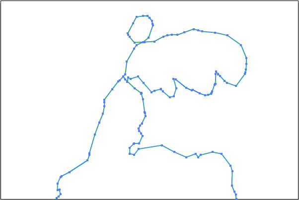
Figure 6. Visualizing track points. Detail from Winged Victory. Walking through the Central Park near the Metropolitan. NYC, USA.
The GPS personal navigation device I have been using for tracing labyrinth trajectories, a Garmin Legend E-Trex, is capable of recording logs in GPX format. I have set up the device to automatically start recording a track log as soon as it gets a satellite location fix. I have also set up the recording interval of track points (digital breadcrumbs) to depend on the changes in speed, direction, and elevation that I make while traversing a city. Every time one of these variables changes, a track point is recorded (a breadcrumb is dropped in the digital map). This method of recording has helped me to visualize and measure not only the different kind of urban movements that one can make but also the various types of urban layouts that characterize each city. For instance, the more turns and detours one makes, the more track points (breadcrumbs) that are recorded and the more texturized the lines (traces) get. The number of track points that are logged during a labyrinth trajectory also depends on the duration of journey and the distance traveled. Among the nine drawings I am presenting, there are long routes that contain as much as 1932 points (Figure 7. Ear) and short itineraries that have as little as 378 track points (Figure 10. Winged Victory)
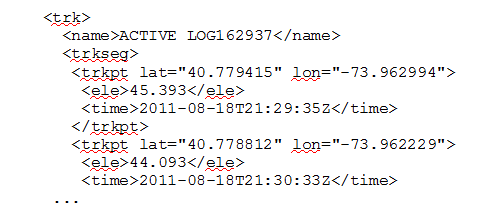
A quick look at one of the GPX files I have recorded let us appreciate the kind of GPS data that is logged and how it is described in the markup language. The basic structure of the file has a major track (
V. Playful Disorientations [Unraveling a Virtual Ariadne’s Thread]
“A line drawing is like taking a dot for a walk.” (Paul Klee)
The most important preparation for logging and drawing labyrinth trajectories in the hybrid physical/virtual space of a city is to have a GPS receiver loaded with minimal geographic data. By lacking geographic data, the GPS receiver will be able to display an empty and almost blank map on its screen. The more basic and emptier the map, the better, so the performer can look at the screen as a blank canvas and draw a trajectory outside the lines of knowledge and geographical control.
Situating himself/herself in public space and faraway from big buildings, the performer turns on the GPS personal navigation device and tunes it to the radio signals of at least four satellites. After getting a fix location, the GPS receiver starts to record an ACTIVE LOG. As soon as the first track point is logged, the performer begins to trace a trajectory by unraveling a virtual Ariadne's thread. Imagining entering a labyrinth as Theseus, one begins to traverse the physical/virtual space of a city guided by the desire of drawing a contour with one single line. As the journey develops and the virtual Ariadne’s thread disentangles, the performer is able to visualize how the one-line drawing progresses. The performer can take conscious decisions about the shapes that she/he want to trace in the hybrid canvas and move in a certain direction in order to alter the form of the line. One should actively make turns and detours that provoke playful disorientations and surprising encounters in the hybrid physical/virtual space. Those kinds of movements are the ones that have more potential for creating suggestive contours and geometries because they allow the performer to actively modify the shape of the labyrinth. By doing turns, loops, and returns, the performer actively make a more curious speech act.
Unlike Theseus the performer of this operation does not need to retrace his steps in order to exit the labyrinth. Instead, thanks to being able to see the complete trace of the virtual Ariadne's thread on the screen (the GPS personal navigation device allows to zoom in and out), she/he can visualize the entrance of the labyrinth and come back to it taking a different route. In fact, following another path is encouraged because in this way the drawing of the trajectory will have an unexpected geometry and the performer will create opportunities for unknown encounters. However, sometimes the exit of the labyrinth does not coincide with the entrance. When this occurs, the performer leaves the one-line drawing open.
VI. Exit. [Souvenirs of Urban Labyrinths]
The urban labyrinths presented below are visualizations of the trajectories recorded while traversing the hybrid physical/virtual space of nine different cities. They are psychogeographical portraits of different urban layouts. Each drawing is displayed separately and is accompanied with information about the number of track points, the distance traversed (Km), the duration of the “speech act” (hh:mm:ss), the kind of urban movement, and the location where they were performed. Although the beauty of these urban labyrinths can be appreciated by contemplating the plasticity of contours, geometries, turns, intersections, and glitches that each of them have, there is also something missing in them. These drawings are representations of an urban speech act that already took place. They are like ghostly traces, visual memories, of a ludic operation in where physical/virtual space was articulated and re-appropriated. It is perhaps due to this fact that they appear to be mysterious and liminal. They are artifacts that resemble a labyrinth that existed once upon a time in an urban hybrid space.
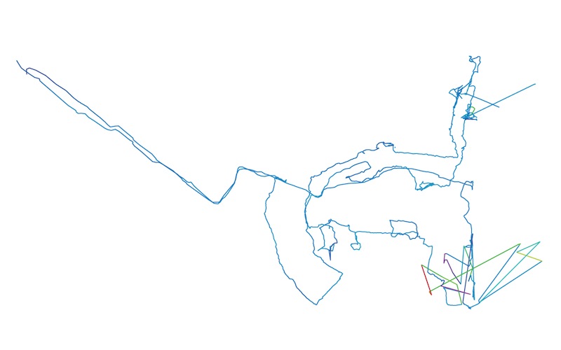
Figure 7. Ear. Amsterdam, NL. Distance: 42.38 Km.Track Points: 1.932 Movement: Walking, Tram.
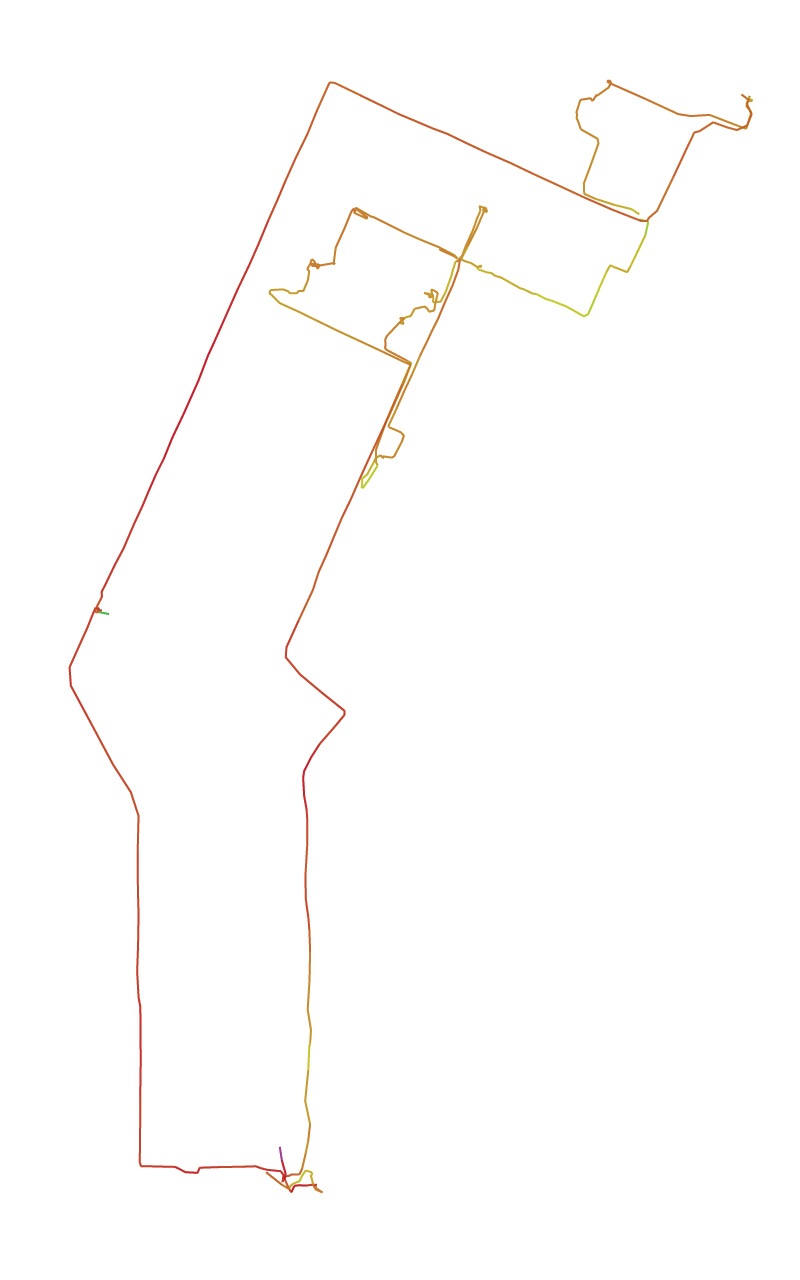
Figure 8. Moon Cow Austin, TX, USA. Distance: 13.11 Km. Track Points: 411 Movement: Cycling.
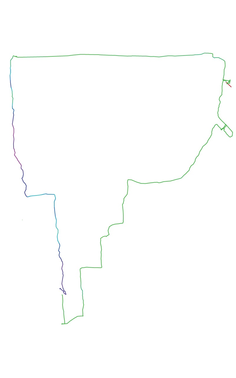
Figure 9. Potato. Bogota, CO. Distance: 8.41 Km Track Points: 469 Movement: Walking
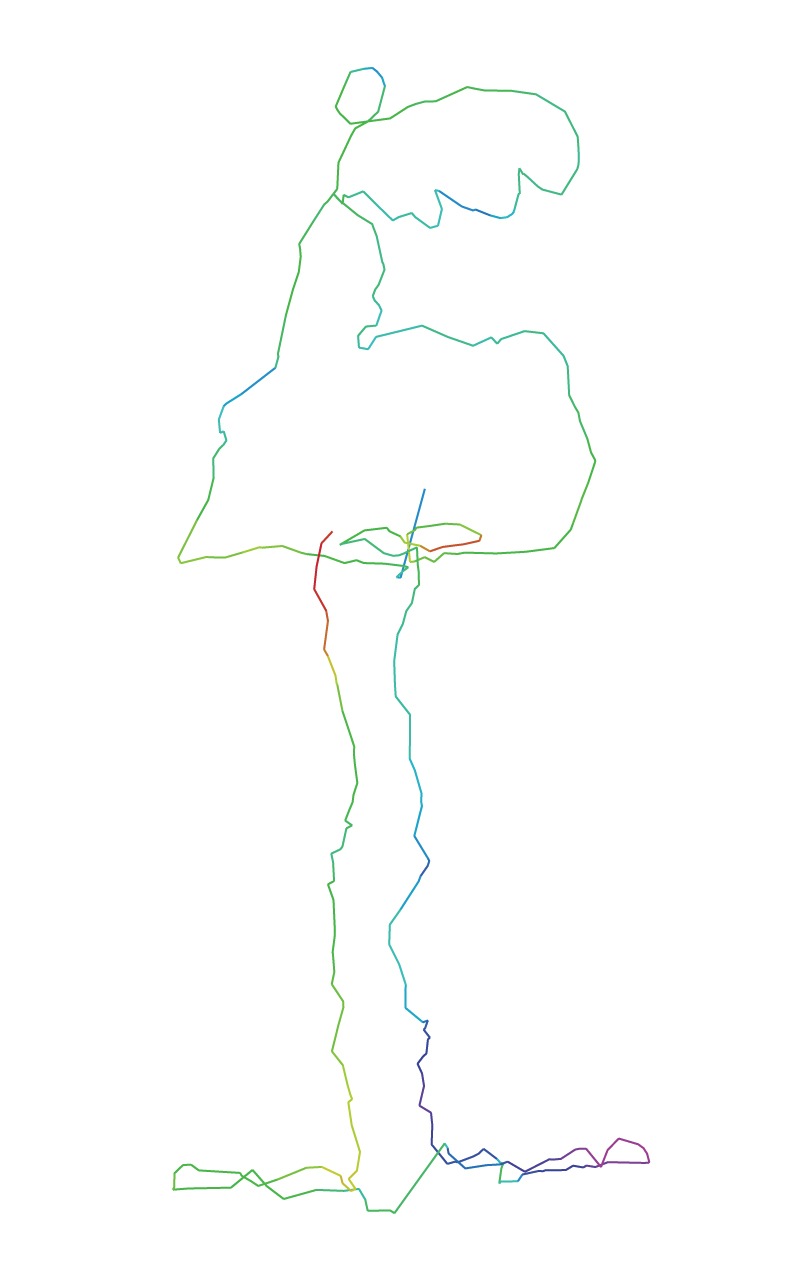
Figure 10. Winged Victory. New York City. NY. USA. Distance: 5.42 Km Track Points: 378. Movement: Walking.
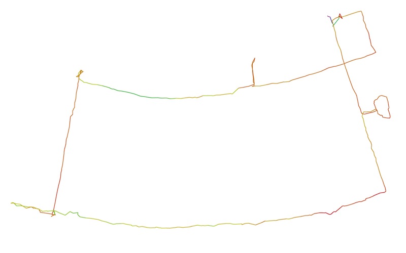
Figure 11. Steam Boat. New Orleans. LO. USA. Track Points: 485 Distance: 6.86 Km Movement: Walking
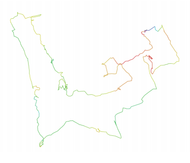
Figure 12. Gargoyle. Paris. FR. Track Points: 578 Distance: 7.78 Km Movement: Walking.
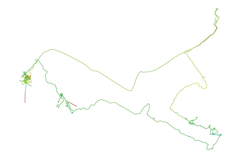
Figure 13. Lion. Prague. CZ. Distance: 21.19 Km. Track Points: 1.116 Movement: Walking, Tram, Bus.
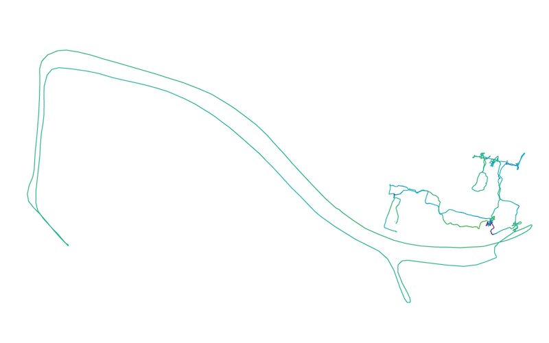
Figure 14. Wale. Rotterdam. NL. Distance: 34.81 Km Track Points: 1220 Movement: Walking, Ship.
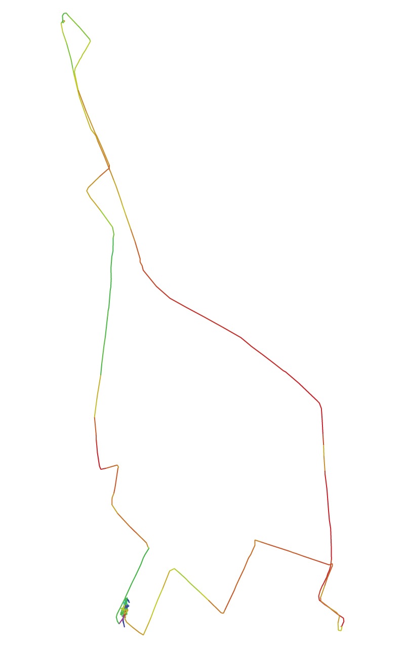
Figure 15. Brontosaurus. Somerville-Cambridge. MA. USA. Distance: 13.55 Km Track Points: 451 Movement: Cycling.
Notes
[1] Mirella Bandini, “Surrealist references in the notions of derive and psychogeography of the situationist urban environment,” in Situacionistas: arte, politica, urbanismo/ Situationists: art, politics, urbanism, eds. Libero Andreotti and Xavier Costa (Barcelona: Museu d’Art Contemporani de Barcelona, 1999), 40-51.
[2] Merlin Coverley, Psychogeography. (Herts: Pocket Essentials, 2006).
[3] Guy Debord, “Introduction to a Critique of Urban Geography, 1955(“Introduction à une critique de la géographie urbaine, 1955”) in Situationist International Anthology, ed. and trans. Ken Knabb (Berkley: Bureau of Public Secrets, 1995).
[4] Guy Debord, “Théorie de la derive, 1958” in Situationist International Anthology, ed. and trans. Ken Knabb (Berkley: Bureau of Public Secrets, 1995)
[5] Michel De Certeau, The Practice of Everyday Life, (Berkeley: University of California Press, 1984), 97.
[6] Michel De Certeau, 98.
[7] Michel De Certeau, 101.
[8] The World Geodetic System was created by the USA Department of Defense in 1984 as part of a planetary mapping program. The WGS84 is the reference coordinate system (datum) used by the Global Positioning System.
[9] John Crandall, “Agency, Mobility, and the Timespace of Tracking,” in Tracing the New Mobilities Regimes (London: Ashgate, 2011); John Crandall, “Operational Media,” CTheory, Jan, (2005). http://www.ctheory.net/articles.aspx?id=441#_ednref29. Brian Holmes, “Drifting Through the Grid: Psychogeography and Imperial Infrastructure,” Media Architecture conference in Riga, May 16-17 (2003). http://www.springerin.at/dyn/heft_text.php?textid=1523&lang=en.
[10] The GPS message format is structured in five subframes. 1: Satellite clock, GPS time relationship. 2–3: Ephemeris (precise satellite orbit). 4–5: Almanac component (satellite network synopsis, error correction).
[11] Rosa Menkman has elaborated a compelling argument about the importance of the glitch (interruptions) for understanding the functioning of technologies. Rosa Menkman, "Glitch Studies Manifesto," in The Glitch Momentum (Amsterdam: Institute of Network Cultures, 2010).
[12] Barry Posen, “Command of the Commons The Military Foundation of U.S. Hegemony,” International Security, Volume 28, Number 1, Summer (2003): 5-46.
[13] The GPS technology universalizes time and space making a data system that is totalitarian. This system is at the core of the global communication infrastructure that serves financial markets, power grids, banking systems, communication networks, and transportation systems.
Andres Lombana Bermudez is a researcher/educator/designer working on the intersection between digital technology, youth, and literacy. He is a PhD candidate in Media Studies at University of Texas at Austin and previously completed a MSc in Comparative Media Studies at the Massachusetts Institute of Technology. Andres is a researcher at the Connected Learning Research Network, and a mentor at the Youth and Media Lab at the Berkman Center for Internet & Society . His current research and design projects focus on digital inequalities, mobile learning, and experimental cartographies.
 Media Fields Journal
Reader Comments